


Summit Peak
Land Surveyor
Land Surveyor
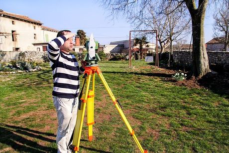
Summit Peak Land Surveyor is a trusted provider of precise and professional land surveying services. With a commitment to accuracy and excellence, we specialize in boundary surveys, topographic mapping, construction staking, and other essential surveying solutions. Our team of experienced surveyors utilizes advanced equipment and technology to ensure reliable results for a wide range of residential, commercial, and industrial projects. We pride ourselves on delivering exceptional customer service and helping our clients confidently plan and execute their projects with a clear understanding of their land and property boundaries.
About Us
At Summit Peak Land Surveyor, we are dedicated to providing high-quality surveying services tailored to meet the unique needs of our clients. Our team consists of highly trained and experienced professionals who bring a wealth of knowledge and expertise in land surveying techniques, modern technologies, and local, state, and federal regulations. We take pride in staying up to date with the latest advancements in the industry to deliver accurate and efficient results. With years of experience and a deep commitment to excellence, we understand the need for a reliable, customer-focused surveying company. Whether you’re a property owner, developer, contractor, or working in another industry, we strive to serve clients across Pasco, WA, and surrounding areas with customized, top-notch surveying solutions.
Our Services
We offer a wide range of surveying services that cater to different needs and requirements. These include property boundary, and title surveys, as well as construction, topographic, and subdivision surveys. Our team also specializes in providing as-built surveys, route surveys, and ALTA/NSPS land title surveys. With our state-of-the-art equipment and cutting-edge technology, we ensure accurate and detailed results for all types of projects. Moreover, we also offer consulting services for clients who need expert advice on surveying-related matters. This includes feasibility studies, land planning, zoning assistance, and mapping services. We understand that every project is unique and may require a different approach; that’s why we work closely with our clients to develop customized solutions that meet their specific needs.

Elevation Certificates
An elevation certificate is an important document for property owners, especially those in flood-prone areas. It provides information about the elevation of a building relative to the base flood elevation (BFE) determined by the Federal Emergency Management Agency (FEMA). This information is crucial for determining flood insurance rates and requirements. At our firm, we have a team of qualified surveyors who are experienced in providing accurate and detailed elevation certificates. We understand that each property is unique and requires individual attention, which is why we take the time to thoroughly assess and measure every aspect of your property to ensure precise results.


ALTA | NSPS | ACSM Land Title Survey
Our land survey company offers comprehensive ALTA/NSPS surveys to meet the needs of our clients. An ALTA/NSPS survey is typically required for commercial properties or for properties involved in real estate transactions. This type of survey not only identifies physical features and boundaries but also includes information on easements, rights-of-way, zoning classifications, and any other relevant data that may affect the property. The ALTA/NSPS standards were developed to ensure consistency and accuracy in land surveys across the United States.

Construction Survey and Stakeout
Construction surveys and stakeouts are essential for any construction project. These types of surveys involve the precise measurement and marking of where structures, roads, utilities, and other features will be built on a property. They play a crucial role in ensuring that the construction is done according to plan and in compliance with legal requirements. They can help to prevent errors and costly mistakes, saving time and money in the long run. Our expert surveyors can provide accurate and reliable construction surveys and stakeouts for all types of projects, ensuring that everything is built to the correct specifications.


Contact Us Today
If you have a project that requires professional surveying services, we would love to hear from you. Our team of experienced professionals is dedicated to providing exceptional results and ensuring client satisfaction. You can reach us through our website or by giving us a call during business hours. We also offer free consultations for potential clients, so don't hesitate to get in touch with us if you have any questions or inquiries. We believe that communication is key for a successful partnership, and we are committed to keeping our clients informed every step of the way.

"Summit Peak Land Surveyor exceeded all our expectations. Their team was professional, thorough, and communicative throughout the entire process. The topographic maps they provided were incredibly detailed and accurate, making our construction project proceed without a hitch. Highly recommended!"

"We hired Summit Peak Land Surveyor for a property boundary survey, and I couldn't be happier with their work. They were punctual, explained every step of the process, and ensured that everything was perfectly clear. Their attention to detail is unmatched. Thank you for making this experience stress-free!"

"Working with Summit Peak Land Surveyor was a fantastic experience. Their crew was knowledgeable and used state-of-the-art equipment to deliver precise results. Thanks to their expertise, our development plans moved forward smoothly. I wouldn’t hesitate to work with them again!"